Copernicus Publications

Geoscientific instrumentation, methods and data systems Template

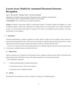
Write in a clean editor, then format for Geoscientific instrumentation, methods and data systems in one click — DocuGuru applies the official Copernicus Publications template with author–year references and exports a submission-ready PDF plus the editable LaTeX source. Free to start.

About the Geoscientific instrumentation, methods and data systems format

Geoscientific instrumentation, methods and data systems is a peer-reviewed journal published by Copernicus Publications, covering Ionosphere and magnetosphere dynamics, Geomagnetism and Paleomagnetism Studies, Geophysical and Geoelectrical Methods.

PublisherCopernicus Publications
Reference styleAuthor–year (Copernicus)
Author–year — (Smith, 2023) in the text
Smith, A., Jones, B., and Lee, C.: A representative article title, Geoscientific instrumentation, methods and data systems, 12, 45–58, 2023.

Formats any DOI in Geoscientific instrumentation, methods and data systems style. No sign-up.

Publishes research inIonosphere and magnetosphere dynamics Geomagnetism and Paleomagnetism Studies Geophysical and Geoelectrical Methods Earthquake Detection and Analysis Geophysical Methods and Applications
ISSN2193-0856
Citation impact (2-yr)1.58
h-index38
i10-index181
Total citations6,175
Article processing charge$1,035
Open accessYes
Top institutions publishing hereFinnish Meteorological Institute
Journal websitewww.geoscientific-instrumentation-methods-and-data-systems.net
You getA submission-ready PDF and the editable LaTeX source — ready to submit.

Papers published in Geoscientific instrumentation, methods and data systems per year

21
2014
22
2015
47
2016
49
2017
29
2018
26
2019
34
2020
26
2021
28
2022
19
2023
29
2024
40
2025

Citation impact of Geoscientific instrumentation, methods and data systems by publication year

312
2014
458
2015
1.2K
2016
703
2017
536
2018
344
2019
483
2020
288
2021
339
2022
87
2023
98
2024
22
2025

Citations each year’s papers have accumulated so far — the most recent years are still building up.

Most-cited papers in Geoscientific instrumentation, methods and data systems

Image georectification and feature tracking toolbox: ImGRAFT

Alexandra Messerli, Aslak Grinsted · 11 Feb 2015

Abstract. The use of time-lapse camera systems is becoming an increasingly popular method for data acquisition. The camera setup is often cost-effective and simple, allowing for a large amount of data to be accumulated over a variety of environments for relatively minimal effort. The acquired data can, with the correct post-processing, result in a wide…

Expanding HadISD: quality-controlled, sub-daily station data from 1931

Robert Dunn, Kate M. Willett, D. E. Parker et al. · 29 Sep 2016

Abstract. HadISD is a sub-daily, station-based, quality-controlled dataset designed to study past extremes of temperature, pressure and humidity and allow comparisons to future projections. Herein we describe the first major update to the HadISD dataset. The temporal coverage of the dataset has been extended to 1931 to present, doubling the time range over which data…

Optimal site selection for sitting a solar park using multi-criteria decision analysis and geographical information systems

Andreas C. Georgiou, Dimitrios Skarlatos · 26 Jul 2016

Abstract. Among the renewable power sources, solar power is rapidly becoming popular because it is inexhaustible, clean, and dependable. It has also become more efficient since the power conversion efficiency of photovoltaic solar cells has increased. Following these trends, solar power will become more affordable in years to come and considerable investments are to be…

Intercomparison of cosmic-ray neutron sensors and water balance monitoring in an urban environment

Martin Schrön, Steffen Zacharias, Gary Womack et al. · 9 Mar 2018

Abstract. Sensor-to-sensor variability is a source of error common to all geoscientific instruments that needs to be assessed before comparative and applied research can be performed with multiple sensors. Consistency among sensor systems is especially critical when subtle features of the surrounding terrain are to be identified. Cosmic-ray neutron sensors (CRNSs) are a recent technology…

Towards a muon radiography of the Puy de Dôme

C. Cârloganu, V. Niess, S. Béné et al. · 6 Feb 2013

Abstract. High-energy (above a few hundred GeV) atmospheric muons are a natural probe for geophysical studies. They can travel through kilometres of rock allowing for a radiography of the density distribution within large structures, like mountains or volcanoes. A collaboration between volcanologists, astroparticle and particle physicists, Tomuvol was formed in 2009 to study tomographic muon…

Geoscientific instrumentation, methods and data systems template — frequently asked questions

How do I write a paper in the Geoscientific instrumentation, methods and data systems format?
In DocuGuru you write your manuscript in a normal editor — no LaTeX setup required — and select the Geoscientific instrumentation, methods and data systems template. When you export, DocuGuru compiles the paper into the official Copernicus Publications format and hands you a submission-ready PDF along with the editable LaTeX source.
What reference style does Geoscientific instrumentation, methods and data systems use?
Geoscientific instrumentation, methods and data systems uses Author–year (Copernicus) references, shown as author–year markers such as (Smith, 2023) in the text. DocuGuru formats every in-text citation and the reference list in this exact style automatically. A reference appears like this: Smith, A., Jones, B., and Lee, C.: A representative article title, Geoscientific instrumentation, methods and data systems, 12, 45–58, 2023.
Do I need to know LaTeX to submit to Geoscientific instrumentation, methods and data systems?
No. DocuGuru generates the copernicus LaTeX class and compiles the PDF for you in the background, so you get a Copernicus Publications-ready Geoscientific instrumentation, methods and data systems document without writing any LaTeX. If you do want it, the LaTeX source is included in the export.
Can I import an existing draft into the Geoscientific instrumentation, methods and data systems template?
Yes. Paste or upload your current manuscript — Word, LaTeX, Markdown, or plain text — and DocuGuru reflows it into the Geoscientific instrumentation, methods and data systems format with correct headings, figures, tables, and author–year citations.
Who publishes Geoscientific instrumentation, methods and data systems?
Geoscientific instrumentation, methods and data systems is a earth and environmental sciences journal published by Copernicus Publications. DocuGuru's Geoscientific instrumentation, methods and data systems template matches Copernicus Publications's official submission format.
Can I export a submission-ready Geoscientific instrumentation, methods and data systems PDF?
Yes — DocuGuru produces a PDF built with the official Geoscientific instrumentation, methods and data systems template (the copernicus class) that is ready to submit to Copernicus Publications, together with the matching LaTeX source files.
How much does the Geoscientific instrumentation, methods and data systems template cost?
You can start writing in the Geoscientific instrumentation, methods and data systems template for free. Exporting the final submission-ready Geoscientific instrumentation, methods and data systems PDF and LaTeX source is part of DocuGuru's paid plans — see the app for current pricing.
Use the Geoscientific instrumentation, methods and data systems template