Taylor & Francis

Journal of Map & Geography Libraries Template

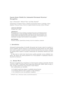
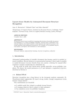
Write in a clean editor, then format for Journal of Map & Geography Libraries in one click — DocuGuru applies the official Taylor & Francis template with author–year references and exports a submission-ready PDF plus the editable LaTeX source. Free to start.

About the Journal of Map & Geography Libraries format

Journal of Map & Geography Libraries is a peer-reviewed journal published by Taylor & Francis, covering Geographic Information Systems Studies, Data Management and Algorithms, Historical Geography and Cartography.

PublisherTaylor & Francis
Reference styleAuthor–year (Chicago, T&F)
Author–year — (Smith, 2023) in the text
Smith, Ada, Ben Jones, and Cara Lee. 2023. "A Representative Article Title." Journal of Map & Geography Libraries 12 (3): 45–58.

Formats any DOI in Journal of Map & Geography Libraries style. No sign-up.

Publishes research inGeographic Information Systems Studies Data Management and Algorithms Historical Geography and Cartography Geography Education and Pedagogy Archaeological Research and Protection
ISSN1542-0353
Citation impact (2-yr)0.75
h-index21
i10-index63
Total citations2,136
Top institutions publishing herePennsylvania State University
Journal websitewww.tandfonline.com
You getA submission-ready PDF and the editable LaTeX source — ready to submit.

Papers published in Journal of Map & Geography Libraries per year

22
2014
24
2015
22
2016
23
2017
11
2018
16
2019
20
2020
10
2021
20
2022
13
2023
12
2024
16
2025

Citation impact of Journal of Map & Geography Libraries by publication year

128
2014
196
2015
112
2016
187
2017
48
2018
79
2019
38
2020
9
2021
39
2022
18
2023
16
2024
7
2025

Citations each year’s papers have accumulated so far — the most recent years are still building up.

Most-cited papers in Journal of Map & Geography Libraries

Crisis Mapping in Action: How Open Source Software and Global Volunteer Networks Are Changing the World, One Map at a Time

Patrick Meier · 1 May 2012

The purpose of this paper is to share the stories behind some extraordinary maps—live crisis maps. The paper begins by investigating what types of live communication technologies existed prior to social media technologies. The development of live crisis maps is then discussed, beginning with the Ushahidi project, which utilized live collaborative mapping during post-election violence…

Wayfinding in Libraries: Can Problems Be Predicted?

Rui Li, Alexander Klippel · 1 Jan 2012

The main library at the authors’ university campus, with its large size and multiple-level structures, is challenging for patrons to navigate. Requests for directions are among the most frequently posed questions at help desks in this library. As a first step toward improving wayfinding aids, such as maps or signs, we took a spatial science…

Crisis Mapping: The Construction of a New Interdisciplinary Field?

Jen Ziemke · 1 May 2012

Abstract This paper summarizes recent developments in crisis mapping and offers a meta-analysis of nascent, community-led conversations about this evolving area of concern. Such discussions occur in diverse fora: from meetings and conference calls with large government agencies to asynchronous email threads, to sessions with nongovernmental agencies, large and small, simulated exercises, and between and…

Topographic Maps: Methodological Approaches for Analyzing Cartographic Style

Alexander J. Kent · 23 Jul 2009

Despite their status and ubiquity, modern state topographic maps are seldom the topic of cartographic research. There is a notable deficiency in the number of empirical studies that investigate their design, or, given their heritage, examine their symbology with a view to identifying the ingredients of style. The issue of stylistic similarities and differences raises…

The National Geospatial Digital Archive: A Collaborative Project to Archive Geospatial Data

Tracey Erwin, Julie Sweetkind-Singer · 31 Dec 2009

The National Geospatial Digital Archive is a collaborative project between the University of California at Santa Barbara and Stanford University. The project was funded by the Library of Congress through their National Digital Information Infrastructure and Preservation Program (NDIIPP). The goal of the collaboration was to collect, preserve, and provide long-term access to at-risk geospatial…

Journal of Map & Geography Libraries template — frequently asked questions

How do I write a paper in the Journal of Map & Geography Libraries format?
In DocuGuru you write your manuscript in a normal editor — no LaTeX setup required — and select the Journal of Map & Geography Libraries template. When you export, DocuGuru compiles the paper into the official Taylor & Francis format and hands you a submission-ready PDF along with the editable LaTeX source.
What reference style does Journal of Map & Geography Libraries use?
Journal of Map & Geography Libraries uses Author–year (Chicago, T&F) references, shown as author–year markers such as (Smith, 2023) in the text. DocuGuru formats every in-text citation and the reference list in this exact style automatically. A reference appears like this: Smith, Ada, Ben Jones, and Cara Lee. 2023. "A Representative Article Title." Journal of Map & Geography Libraries 12 (3): 45–58.
Do I need to know LaTeX to submit to Journal of Map & Geography Libraries?
No. DocuGuru generates the interact LaTeX class and compiles the PDF for you in the background, so you get a Taylor & Francis-ready Journal of Map & Geography Libraries document without writing any LaTeX. If you do want it, the LaTeX source is included in the export.
Can I import an existing draft into the Journal of Map & Geography Libraries template?
Yes. Paste or upload your current manuscript — Word, LaTeX, Markdown, or plain text — and DocuGuru reflows it into the Journal of Map & Geography Libraries format with correct headings, figures, tables, and author–year citations.
Who publishes Journal of Map & Geography Libraries?
Journal of Map & Geography Libraries is a multidisciplinary journal published by Taylor & Francis. DocuGuru's Journal of Map & Geography Libraries template matches Taylor & Francis's official submission format.
Can I export a submission-ready Journal of Map & Geography Libraries PDF?
Yes — DocuGuru produces a PDF built with the official Journal of Map & Geography Libraries template (the interact class) that is ready to submit to Taylor & Francis, together with the matching LaTeX source files.
How much does the Journal of Map & Geography Libraries template cost?
You can start writing in the Journal of Map & Geography Libraries template for free. Exporting the final submission-ready Journal of Map & Geography Libraries PDF and LaTeX source is part of DocuGuru's paid plans — see the app for current pricing.

Use the Journal of Map & Geography Libraries template