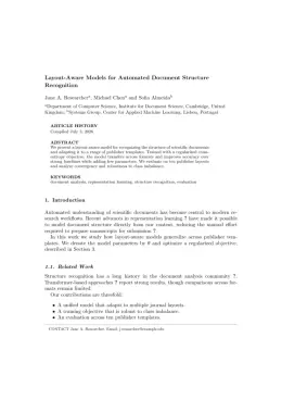
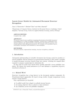
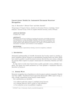
Taylor & Francis

International Journal of Geographical Information Systems Template

Write in a clean editor, then format for International Journal of Geographical Information Systems in one click — DocuGuru applies the official Taylor & Francis template with author–year references and exports a submission-ready PDF plus the editable LaTeX source. Free to start.

About the International Journal of Geographical Information Systems format

International Journal of Geographical Information Systems is a peer-reviewed journal published by Taylor & Francis, covering Geographic Information Systems Studies, Data Management and Algorithms, Land Use and Ecosystem Services.

PublisherTaylor & Francis
Reference styleAuthor–year (Chicago, T&F)
Author–year — (Smith, 2023) in the text
Smith, Ada, Ben Jones, and Cara Lee. 2023. "A Representative Article Title." International Journal of Geographical Information Systems 12 (3): 45–58.

Formats any DOI in International Journal of Geographical Information Systems style. No sign-up.

Publishes research inGeographic Information Systems Studies Data Management and Algorithms Land Use and Ecosystem Services Human Mobility and Location-Based Analysis 3D Modeling in Geospatial Applications
ISSN0269-3798
Citation impact (2-yr)5.32
h-index176
i10-index2,219
Total citations165,421
Top institutions publishing hereWuhan University
You getA submission-ready PDF and the editable LaTeX source — ready to submit.

Papers published in International Journal of Geographical Information Systems per year

108
2014
173
2015
116
2016
105
2017
128
2018
132
2019
112
2020
86
2021
89
2022
81
2023
138
2024
152
2025

Citation impact of International Journal of Geographical Information Systems by publication year

5.9K
2014
6.8K
2015
5.9K
2016
4.9K
2017
4.9K
2018
5.8K
2019
4.3K
2020
2.4K
2021
2.1K
2022
1.3K
2023
1.4K
2024
372
2025

Citations each year’s papers have accumulated so far — the most recent years are still building up.

Most-cited papers in International Journal of Geographical Information Systems

Geographical Detectors‐Based Health Risk Assessment and its Application in the Neural Tube Defects Study of the Heshun Region, China

Jinfeng Wang, Xin‐Hu Li, George Christakos et al. · 1 Jan 2010

Physical environment, man‐made pollution, nutrition and their mutual interactions can be major causes of human diseases. These disease determinants have distinct spatial distributions across geographical units, so that their adequate study involves the investigation of the associated geographical strata. We propose four geographical detectors based on spatial variation analysis of the geographical strata to assess…

2,648 citations Cite SaveGo to paper →
GIS‐based multicriteria decision analysis: a survey of the literature

Jacek Malczewski · 23 Jun 2006

The integration of GIS and multicriteria decision analysis has attracted significant interest over the last 15 years or so. This paper surveys the GIS‐based multicriteria decision analysis (GIS‐MCDA) approaches using a literature review and classification of articles from 1990 to 2004. An electronic search indicated that over 300 articles appeared in refereed journals. The paper…

2,193 citations Cite SaveGo to paper →
Kriging: a method of interpolation for geographical information systems

Margaret A. Oliver, R. Webster · 1 Jul 1990

Geographical information systems could be improved by adding procedures for geostatistical spatial analysis to existing facilities. Most traditional methods of interpolation are based on mathematical as distinct from stochastic models of spatial variation. Spatially distributed data behave more like random variables, however, and regionalized variable theory provides a set of stochastic methods for analysing them.…

2,174 citations Cite SaveGo to paper →
Point-set topological spatial relations

Max J. Egenhofer, Robert Franzosa · 1 Jan 1991

Abstract Practical needs in geographic information systems (GIS) have led to the investigation of formal and sound methods of describing spatial relations. After an introduction to the basic ideas and notions of topology, a novel theory of topological spatial relations between sets is developed in which the relations are defined in terms of the intersections…

1,651 citations Cite SaveGo to paper →
Geographically and temporally weighted regression for modeling spatio-temporal variation in house prices

Bo Huang, Bo Wu, Michael Barry · 10 Mar 2010

Abstract By incorporating temporal effects into the geographically weighted regression (GWR) model, an extended GWR model, geographically and temporally weighted regression (GTWR), has been developed to deal with both spatial and temporal nonstationarity simultaneously in real estate market data. Unlike the standard GWR model, GTWR integrates both temporal and spatial information in the weighting matrices…

1,456 citations Cite SaveGo to paper →

International Journal of Geographical Information Systems template — frequently asked questions

How do I write a paper in the International Journal of Geographical Information Systems format?
In DocuGuru you write your manuscript in a normal editor — no LaTeX setup required — and select the International Journal of Geographical Information Systems template. When you export, DocuGuru compiles the paper into the official Taylor & Francis format and hands you a submission-ready PDF along with the editable LaTeX source.
What reference style does International Journal of Geographical Information Systems use?
International Journal of Geographical Information Systems uses Author–year (Chicago, T&F) references, shown as author–year markers such as (Smith, 2023) in the text. DocuGuru formats every in-text citation and the reference list in this exact style automatically. A reference appears like this: Smith, Ada, Ben Jones, and Cara Lee. 2023. "A Representative Article Title." International Journal of Geographical Information Systems 12 (3): 45–58.
Do I need to know LaTeX to submit to International Journal of Geographical Information Systems?
No. DocuGuru generates the interact LaTeX class and compiles the PDF for you in the background, so you get a Taylor & Francis-ready International Journal of Geographical Information Systems document without writing any LaTeX. If you do want it, the LaTeX source is included in the export.
Can I import an existing draft into the International Journal of Geographical Information Systems template?
Yes. Paste or upload your current manuscript — Word, LaTeX, Markdown, or plain text — and DocuGuru reflows it into the International Journal of Geographical Information Systems format with correct headings, figures, tables, and author–year citations.
Who publishes International Journal of Geographical Information Systems?
International Journal of Geographical Information Systems is a multidisciplinary journal published by Taylor & Francis. DocuGuru's International Journal of Geographical Information Systems template matches Taylor & Francis's official submission format.
Can I export a submission-ready International Journal of Geographical Information Systems PDF?
Yes — DocuGuru produces a PDF built with the official International Journal of Geographical Information Systems template (the interact class) that is ready to submit to Taylor & Francis, together with the matching LaTeX source files.
How much does the International Journal of Geographical Information Systems template cost?
You can start writing in the International Journal of Geographical Information Systems template for free. Exporting the final submission-ready International Journal of Geographical Information Systems PDF and LaTeX source is part of DocuGuru's paid plans — see the app for current pricing.

Use the International Journal of Geographical Information Systems template